|
Cold
Front of the 24th September 2007 |
|
Data
showing the cold front passing through at
around 04:30 this morning here in the Otter
Valley:
|
|
Time |
Temp |
Rain |
Wind |
(mph) |
(mb) |
DP |
|
04:00 |
16.0C |
0.6 |
SSW |
18 |
1002.7 |
14.9C |
|
04:15 |
16.0C |
0.4 |
S |
16 |
1002.4 |
14.8C |
|
04:30 |
15.9C |
0.0 |
SSW |
12 |
1002.2 |
14.7C |
|
04:45 |
14.8C |
6.2 |
W |
9 |
1003.3 |
13.3C |
|
05:00 |
13.5C |
1.0 |
WSW |
6 |
1003.6 |
12.0C |
|
05:15 |
13.0C |
0.0 |
WSW |
9 |
1004.0 |
11.5C |
|
05:30 |
12.7C |
0.6 |
W |
6 |
1004.2 |
11.3C |
|
05:45 |
12.5C |
0.4 |
WNW |
5 |
1004.4 |
11.1C |
|
06:00 |
12.4C |
0.4 |
WNW |
4 |
1004.1 |
10.9C |
|
|
It was
certainly wild, wet and windy for a short
time. Max gust was 36 mph at 04:00. The
temperature was reasonably constant for most
of the night at around 16C until 04:30 then
it dropped 3.3C in one hour as the cold
front passed through. A total of 15.7 mm of
rain fell throughout the night ending a
drought which had lasted 32 days; since the
24th of August. Tornadic activity as a
result of this cold front was reported in
the Midlands, with roofs of houses being
torn off and windows blown in. |
|
 |
Pressure chart for 06:00 on Monday 24th September 2007. The
cold front can clearly be seen lying north to south across
the East Midlands.
|
|
 |
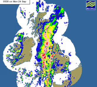 |
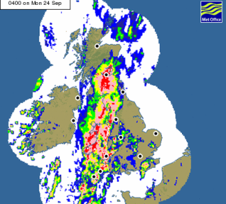
Met
Office rainfall radar showing the rain falling across
the UK at 04:00 and 05:30 on the 24th of September 2007.
At 05:30 the trailing edge of the heavy rain had reached
Exeter.
|
|
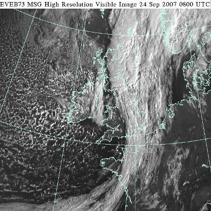 |
Visible satellite picture taken at 09:00 BST on the 24th
September 2007, clearly showing the cold front lying
over eastern England.
|
|
|
|