|
Otter Valley Webcam Video Gallery
(2013) Time-lapse videos of the southern sky above the Otter Valley, Devon |
||||||||||||||||||
| 7th May 2013: Strong sunshine evaporates early cloud then sunny until mid-afternoon. | ||||||||||||||||||
| Weak weather fronts moving in from the south-west in a slack southerly air flow. Mist and low cloud soon evaporated under the strong May sunshine leaving clear skies. Then high cirrus cloud moved in from the west turning the sunshine very hazy. Finally as the afternoon progressed, cloud moved in from the south and the wind started to pick up leading to a breezy but dry evening. This marked the end of a week-long settled spell of weather. | ||||||||||||||||||
| Extremes and totals for 7th May 2013 | ||||||||||||||||||
|
||||||||||||||||||
 |
||||||||||||||||||
| 19th March 2013: A fine start then cloud builds | ||||||||||||||||||
|
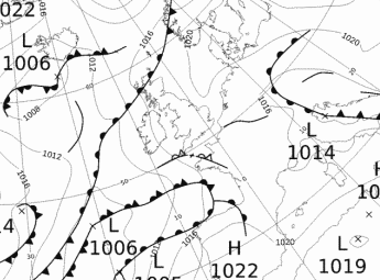
A complex area of low pressure was situated over the British Isles with the centre towards South West England. The Otter Valley was under a slack air flow with variable direction. The day dawned clear but the sun's warming of the ground soon allowed for cumulus build up, and a gentle sea breeze from the south sprung up from late morning onwards. It was a dry day despite heavy, often dark cloudy skies during the afternoon. On this time-lapse footage the sun does bleach-out the video somewhat at first but when the cloud builds up then definition is restored. |
||||||||||||||||||
| Extremes and totals for 19th March 2013 | ||||||||||||||||||
|
||||||||||||||||||
 Met Office Chart 19/3/13 |
||||||||||||||||||
| Home | Data | Live | Other Webcams | Station | Climate | Gallery | Contact | Links | ||||||||||||||||||