|
Otter Valley Webcam Video Gallery
(2012) Time-lapse videos of the southern sky above the Otter Valley, Devon |
|||||||||||||
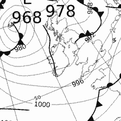
| 3rd November 2012: A sunny, cold start then increasing cloud and wind | |||||||||||||
|
A low pressure system was centred to the north-west of the British Isles. The Otter Valley was in a slack maritime polar air stream to start the 3rd but slowly the isobars tightened and the wind increased through the day. There was a developing low pressure area to the south over Brittany but this did not affect here until the early hours of the 4th. There were showers around, but these mainly formed over the sea and quickly died out over land. |
|||||||||||||
Extremes and
totals for 3rd November 2012
|
|||||||||||||
 |
|||||||||||||
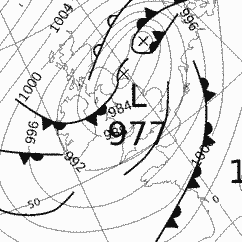
| 25th September 2012: A bright day with cumulus build up after a clear start | |||||||||||||
|
A deep low pressure system was centred over northern England and the Otter Valley was in a brisk NW airflow. Despite a showery airstream, the showers mainly affected north and west coasts and it stayed dry. The low pressure was spawned from tropical air being pushed northwards ahead of Hurricane Nadine. With warm air aloft, rainfall amounts were very high across many parts of northern England. |
|||||||||||||
Extremes and
totals for 25th September 2012
|
|||||||||||||
 |
|||||||||||||
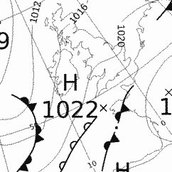
| 21st August 2012: A cloudy start, then a westerly wind and a sunny afternoon | |||||||||||||
|
With a small ridge of high pressure to the south west of the British Isles it made for a fine day in the Otter Valley, after a cloudy start. There were decaying weather fronts to the south and west but they stayed well away making sure that things remained dry for this weather station, though there were a few, sharp showers further inland. |
|||||||||||||
Extremes and
totals for 21st August 2012
|
|||||||||||||
 |
|||||||||||||
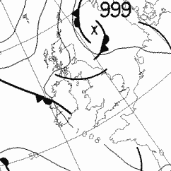
| 13th April 2012: A chaotic cirrus sky and a sun halo too | |||||||||||||
| With high
pressure centred to the north west, there was a slack northerly flow
over the whole of the British Isles bringing a showery regime. Here
in the Otter Valley, heavy, thundery showers developed just a few
kilometres inland but here near the coast a sea breeze meant it was
dry and mostly sunny, though that sunshine was rather hazy at times. Extremes and totals for 13th April 2012
|
|||||||||||||
 |
|||||||||||||
| UV Light | Month So Far | Year So Far | Recording Data | Time-Lapse Videos | World Weather | Met Office 5-Day | Humidity Calculation | Links | |||||||||||||